


A reef goes from unknown to bookable through a slow, unglamorous sequence: local fishers already know it, a dive operator gets curious, someone logs coordinates and depth profiles, an SSI or PADI center starts running trips there, dive magazines pick it up, and eventually satellite imagery and conservation surveys confirm what the divers already suspected. Indonesia's coastline runs over 54,000 kilometers, sitting inside the Coral Triangle, so this process is still active in 2026. Most "new" dive sites were never actually new to the people living beside them.
TL;DR
- New dive sites in Indonesia typically start as local fishing knowledge before any dive operator visits them.
- Small, on-site dive centers with resident staff discover and log far more first-hand reef data than fly-in liveaboards passing through once a season.
- Documentation (GPS coordinates, depth, visibility, species logs) is what separates a rumor from a mapped, repeatable dive site.
- Remote archipelagos like the Togean Islands still have reef systems that get logged for the first time as a routine part of daily diving operations.
- Reef discovery and reef protection move together. A site nobody has logged is also a site nobody is watching for damage.
Why Do Some Indonesian Reefs Stay Undocumented for Decades?
A reef stays off the dive map for one practical reason: nobody with the training and incentive to document it has spent enough time there. Indonesia's outer islands number in the thousands, and dive tourism infrastructure concentrates in a handful of well-known hubs: Bali, Raja Ampat, Komodo, Bunaken.
Everywhere else is a gap not because the reefs are lesser, but because logging a site requires repeat visits, not a single trip.
Three factors keep a reef undocumented:
- Access difficulty. Sites reachable only by multi-leg boat journeys see fewer dive operators willing to base themselves there long-term.
- No resident dive center. Liveaboards pass through once or twice a season; they rarely have the continuity to build a depth profile or a species log over multiple years.
- No local dive-trained population. Fishers and villagers often know exactly where the walls and pinnacles are, but without SSI or equivalent training, that knowledge doesn't turn into logged, divable data.
Local ecological knowledge is usually accurate on location and depth, but it's oral, not documented. Turning "there's a drop-off past the second point" into a named, GPS-tagged, depth-profiled dive site is a specific piece of work. It's the missing link in most undived regions.
What Actually Happens Between "Local Knowledge" and "On the Map"?
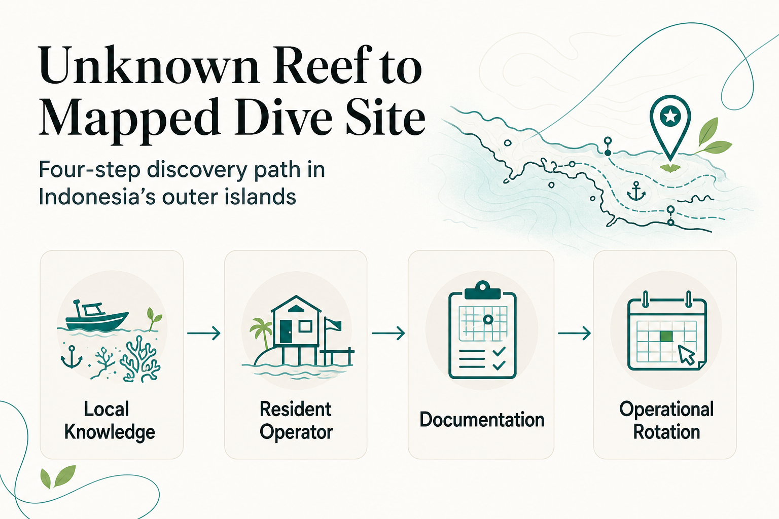
The path from rumor to reality is consistent across Indonesia's remote diving regions, whether it's the Togeans, Alor, or the Banda Sea.
Step 1: Local knowledge surfaces
Fishers, boat captains, and village residents already know where the fish congregate and where the seabed drops off. This is almost always the starting point. Dive operators who build genuine relationships with neighboring villages get access to this knowledge years before any survey team arrives.
Step 2: A resident operator investigates
Someone with dive training and equipment does an exploratory dive. This is where a resident, on-site dive center has a structural advantage over a visiting boat: repeat access lets a team check the same site across tide conditions, seasons, and visibility ranges before calling it reliable.
Step 3: The site gets documented
Documentation means GPS coordinates, a depth profile, notes on current and entry point, and a visibility record across at least one full season. Without this step, a site is a story, not a dive site. This is the step most informal "hidden gem" reports skip entirely, which is why so many of them turn out to be unreliable or dangerous when other divers try to follow up.
Step 4: It enters operational rotation
Once documented, a site gets added to a dive center's regular site list and briefed to instructors. From there it can appear in guest logs, magazine features, and eventually in third-party dive guides and conservation databases.
Why Does a Resident Dive Center Find More New Sites Than a Liveaboard?
A liveaboard moving through a region on a fixed itinerary has strong incentives to dive known, reliable sites. Time is limited and guest expectations are set. There's no return trip next month to check whether yesterday's promising drop-off actually holds up in different current conditions.
Exploration is expensive when your business model depends on a tight schedule.
A resident, small-scale dive center works differently. Diving the same waters daily across an entire season means:
- Current patterns around specific points get learned firsthand, not estimated from a chart.
- Visibility changes, which average about 30 meters in the Togean Islands, get tracked across wet and dry months rather than guessed at from a single visit.
- A pinnacle that looked marginal in March can get revisited in July when conditions are different.
This is less about ambition and more about structure. It's the same reason a local shopkeeper knows more about which afternoons are quiet than a delivery driver passing through once a week. Repetition builds a kind of knowledge that a single visit can't.
Where Does the Togean Islands Sit in This Discovery Process?
The Togean Islands in Central Sulawesi sit inside this same pattern. It's a marine environment with reef systems, walls, and pinnacles that don't all appear in dive guides yet, precisely because dive infrastructure here is newer and smaller-scale than in Bali or Raja Ampat. Reconnect is a gateway to Togean Islands National Park.
At Reconnect, our SSI-certified dive center operates directly from Buka Buka Island, with short boat rides to reef sites rather than long transfers. That combination-resident instructors, daily access, repeat visits across seasons-is exactly the structure that turns local reef knowledge into documented dive sites over time.
This is also why an eco-resort in Indonesia with an on-site dive center behaves differently from a hotel that simply arranges dive trips through a third party. Instructors who live and work on the same reef system for years accumulate the kind of site knowledge that a rotating roster of contracted guides cannot.
Does Discovery Put a Reef at Risk?
A fair question, and the honest answer is: it can, if discovery isn't paired with monitoring. A newly mapped site that gets published without any ongoing oversight can see dive traffic increase faster than anyone is tracking impact. This is a genuine tension in dive tourism, not a hypothetical one.
The way to manage it isn't to keep sites hidden. It's to make sure discovery and monitoring happen together, through certified dive operations rather than informal, unverified trip reports. A Blue Oceans certified dive center, for instance, operates under standards for reef-safe practices as part of daily operations, which matters more once a site starts seeing regular traffic. Unmonitored resource use, whether on land or reef, tends to accelerate once access improves without matching oversight. Marine tourism carries the same risk if growth outpaces documentation and stewardship.
Frequently Asked Questions
How long does it typically take for a new dive site to become well known?
Multiple seasons of repeat diving and documentation is the norm before a site appears reliably in dive guides or magazine coverage.
Do local fishing communities get credited when a dive site is discovered this way?
Reputable operators building supplier and village partnerships typically do acknowledge and compensate local knowledge, though formal recognition varies by operator and region.
Is it safe to dive a site that isn't officially documented yet?
Only with a trained, resident dive operator who has personally checked current, depth, and entry conditions. An undocumented site with no local operational history carries real risk.
Are there still truly undived reefs left in Indonesia's outer islands?
Given the scale of Indonesia's coastline and the concentration of dive infrastructure in a few hubs, yes, particularly in less-visited archipelagos like the Togeans.
About Reconnect
Reconnect is a private island eco-resort on Buka Buka Island in the Togean Islands, Central Sulawesi, with an on-site SSI-certified dive center and 20 rooms. We run 93% solar-powered, all-inclusive from EUR 60/night, with instruction in English, French, and Indonesian. Get in touch through reconnect.id.
References
- Indonesia Deforestation Rates & Statistics | GNW (globalnaturewatch.org)
- The status of deforestation in Indonesia in 2025 - Rainforest Rescue (rainforest-rescue.org)